For some researchers, personal experience sparks innovation.
“Since childhood, I’ve had issues seeing in low light,” says Lehigh University Professor Vinod Namboodiri. “And I always wondered about people who are completely blind: How do they get around? So as an academic with a background in computing, wireless communications, and networks, I knew I had the skills and the personal connection that could help me solve a problem faced by so many people with disabilities—how to confidently get from point A to point B when inside unfamiliar spaces.”
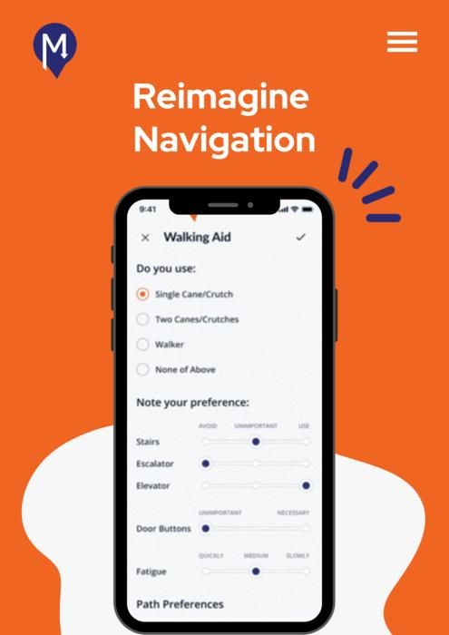
Namboodiri, a faculty member in both the P.C. Rossin College of Engineering and Applied Science and the College of Health, recently received funding from the National Science Foundation’s Convergence Accelerator program to advance from Phase 1 to Phase 2 of the program’s Enhancing Opportunities for Persons with Disabilities track. The computer scientist and his team—which includes partners such as Good Shepherd Rehabilitation, the Smithsonian’s museums in Washington, D.C., and the American Foundation for the Blind, among others—will use the three-year grant to build a prototype of a personalized, scalable app, called MABLE (Mapping for Accessible BuiLt Environments), that will allow people with a range of impairments to get turn-by-turn instructions when navigating indoor environments.
The award is part of a total investment of $30 million that the NSF is spreading across six multidisciplinary research teams to develop systems, technologies, and tools to enhance the quality of life and improve the employment opportunities of those with disabilities.
Namboodiri’s app builds upon work he began as a faculty member at Wichita State University after spending a sabbatical at Envision. The nonprofit, which is based in Kansas and Texas, serves people who are blind or visually impaired through employment, education, research, rehabilitation, and outreach.
“While I was there, I learned about the different challenges these people faced,” he says, “and it became clear that while Google Maps and Apple Maps allowed them to find their way outdoors fairly easily, they really struggled once they walked into a mall or into a store.”
Soon, however, he realized it wasn’t just blind or visually impaired people who had a hard time navigating these environments.
“Those who use wheelchairs often have a tough time locating the most accessible routes, like where the ramps or elevators are in a building,” he says. “Similarly, older adults and those with cognitive impairments might get from point A to point B, but then have difficulty finding their way back to point A. It became clear that people with disabilities face a lot of anxiety when they visit new spaces, and so the question became, How can we use a computing and engineering perspective to solve some of these challenges?”
Namboodiri plans to create a smartphone way-finding app that can be personalized to the specific needs of the user. But he and his team must first overcome two vexing problems: the absence of a universal positioning system—like the satellites that power navigation apps—and a dearth of maps for indoor spaces.
To address the former, Namboodiri deployed wireless devices called beacons within a single academic building as part of what he calls a “low-fidelity prototype” he developed while at Wichita State.
“We spread them around the building, and smartphones connected to them through Bluetooth. So as you got closer to them, the phone knew where you were, and in that way, it kind of mimicked the satellite system.”
Such beacons may be the answer going forward, he says, but his team is working on alternative methods of orientation, such as using the phone’s camera or video capabilities.
“We don’t want to marry ourselves to one approach because there may be some building owners who don’t want to use beacons due to the need to add them to existing built environments,” he says. “Camera-based approaches are increasingly viable due to greater computing capabilities, but some users do not want to use them due to extensive smartphone battery drain. Coarser positioning schemes based on Wi-Fi and Inertial Motion Units may be sufficient for some users, but are inadequate for those that need more precise location and associated contextual information. So while this project started with beacons, we’ll be pursuing a much broader range of possibilities that allows building managers to choose what they want to offer for their end-user base and users to voice their opinion on what they prefer.”
The lack of comprehensive indoor maps poses a unique challenge. When floor plans do exist for a given building, it’s rare that they contain the level of detail that would make them useful to those with visual, mobility, or cognitive impairments. Namboodiri and his team of collaborators plan to design scalable, automated approaches to convert floor plans to maps and then leverage crowdsourcing to enable users to contribute the information that will make the plans relevant to a diverse range of needs. And they’ll be available not only within the mobile app, but online as well, all in accessible formats personalizable by a diverse set of users to their specific needs.
“The app will allow independent way finding,” he says, “but say you’re planning on going to a conference in a hotel. You’ll be able to use your web browser to study the maps and plan out the best routes ahead of time, so when you arrive, you’ll already know where you’re going, in a sense.”
He says the long-term vision is to provide a service in which the appropriate tools, software, and algorithms are available for purchase online for owners interested in making their buildings more accessible.
“So maybe there’s a lower cost service for owners who can do everything on their own, and a specialist service they can hire for more complex buildings,” says Namboodiri.
That future service could also become attractive to an even wider audience, like tourists and firefighters. That’s because Vinod sees way finding as a base layer of sorts—once you have the ability to know where you are and to get routes within a building, the potential applications are vast. Tourists traveling abroad could use the service inside transit stations and get information on arrivals and departures in their own language. Firefighters could navigate when they’re otherwise blinded by smoke. And it could be used in situations requiring emergency evacuations from a building when the typical exits are blocked.
“Once you have the core functionality of the map and the location, you can add so much on top of that,” he says. “The ultimate goal is to make people with disabilities—and anyone else—visit unknown spaces more confidently.”
It’s a goal that is especially meaningful to him. And it’s one that could have profound ripple effects on society at large.
“Within the U.S., around 25 percent of the population identify as having some kind of disability,” he says. “If we can make it less stressful and easier for them to get around, not only will the quality of their lives improve, but it could help increase their participation in the workforce. And that would be a huge boost to the economy.”