Building resilience
What would be the consequences of a storm like Hurricane Sandy hitting your city? If you could simulate the impact a superstorm of that magnitude would have on your roads and power lines, you could make better decisions to fortify your infrastructure. That’s the goal of the Probabilistic Resilience Assessment of Interdependent Systems (PRAISys), a multimillion-dollar project funded by the NSF that includes three universities, two research centers, six departments, and more than 50 people.
The project came in response to a federal mandate for municipalities to conduct resilience assessments. “The goal was to create a simulator of the damage caused by a hazard, and the decision-making and recovery processes that follow,” says Paolo Bocchini, an associate professor of civil and environmental engineering and a member of the PRAISys team. “We’re doing a scenario-based analysis that looks at damage caused by hurricanes or earthquakes on three systems—transportation, power, and communications.”
The team focused heavily on interdependencies between those systems, and their effect on recovery. The more interdependencies they introduced into their model, the more challenging the recovery.
“So one of the conclusions,” says Bocchini, “is if a power company is looking at either building a second transmission line or retrofitting a line, the best option may be to do neither and instead have a temporary bridge available in case the department of transportation can’t respond quickly enough. Because we included how all these systems rely on each other, the model allows you to think outside the box and find new solutions to these problems.” The project is in its fifth and final year, and has begun beta testing.
Assessing safe passage
Climate change will ultimately affect our bridges. But to what extent?
“We know it will increase the frequency and intensity of hurricanes and extreme rains,” says David Yang, a postdoctoral research associate in civil and environmental engineering. “We were looking at increased temperature and increased precipitation and their impact on bridge safety. The challenge was that we didn’t know how to quantify those impacts to predict scour risk.”
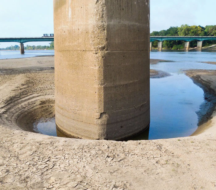
Scour is created when floodwaters erode the materials around a bridge’s foundation, creating scour holes that compromise the integrity of the structure. It’s the primary source of bridge failure in the United States.
Together with Dan M. Frangopol, a professor of civil engineering and the Fazlur R. Khan Endowed Chair of Structural Engineering and Architecture, Yang filled the gap between climate data and structural safety quantification by using hydrologic modeling to convert climate simulation data to flow discharge data in the Lehigh River. “We took a holistic approach,” says Yang. “It started with a global climate model that was downscaled to regional hydrology, then we used structural engineering to get the failure probability of a structure in a future flooding event. We could then assess, does this failure pose risks to a community? So our model included climatology, hydrology, structural engineering, and risk assessment.”
Perhaps their most important conclusion involved the question of mitigation. Specifically, what engineering measures should be deployed to reduce risk, and in which bridges. “Budgets are limited,” says Frangopol. “So it’s important to determine, what is the priority here? We wanted to devise something that the community can use to become adaptive to future climate change.” The pair published their paper in the ASCE Journal of Bridge Engineering.
|
Photo credit: Mike Mareen/iStock, USGS |
Interpreting floodwaters
“Scour is the main cause of failure to structures like retaining walls that protect river banks,” says Panayiotis Diplas, P.C. Rossin Professor and Chair of Civil and Environmental Engineering. “We’re looking at ways to protect those structures and mitigate the impact of floods.”
As such, Diplas and one of his team members are simulating flooding situations in lab flumes. State-of-the-art equipment helps them monitor the scour process taking place in the vicinity of those retaining walls and other structures and better understand the mechanism by which it happens. The goal is twofold: to predict the scour and learn how to reduce its extent. “A proper engineering approach might be to weaken the agent responsible for local scour, meaning the hydrodynamic forces caused by flowing water. If we do that, we can avoid or reduce the extent, especially the depth, of scour.”
Consistent with prior studies, the team has identified the development of a horseshoe vortex as primarily responsible for the erosional process. Diplas and his students are also researching how major floods tend to change the dimensions of a river channel, and how these dimensions can be correlated with major rainfall events.
“If we’re expecting climate change to generate more intense rainfall events, then potentially we can predict how the river will adjust. This will then guide the selection of the site to build a structure,” he says. “If you don’t allow for that adjustment and you interfere with nature, you can expect an increase in flooding in surrounding communities and enhanced damage in our infrastructure. Identifying the impacts of climate change is just very complicated and multifaceted.”
Photo credit: Mike Mareen/iStock, USGS


